Bad location of cellular GPS data
Hi all
My problem started directly after I cracked my screen Iphone 6, which is when I am connected to WIFI fix my results of location and works fine, but when I use the cell data 3G or 4G cards gives me a bad place with 3-4 KM away from my right position and when I start the game requiring my position as (POKÉMON GO) the game says that it has NOT of SIGNAL GPS , but with Wi - FI connection, there is a signal with the right place and everything works well I tried settings > reset > Reset location & privacy I tried alos for update and restore my device, but nothing does not knowing that after I cracked my screen and replace it with an onther one my WIFI signal becames very weack which means I should be nearby wireless to connect I don't know where my problem was perhaps because I broke my screen, I hope you understand me and I hope to find a good solution.
I use Iphone 6 (IOS 9.3.3), 128 GB, thank you
Badr
Where Apple has replaced the screen, bring to them, repairs performed by Apple are covered by a short warranty period.
If you or an unauthorized repair facility did this, Apple will not serve the device and you can only hope they can fix this new.
Find an Apple authorized service provider
Make an appointment at the Apple Store
Tags: iPhone
Similar Questions
-
How to force the Photos up-to-date original jpeg file after you have added the GPS data and rotation
Hello
Pictures has the ability to add GPS data to an image file, but stores the GPS data in a catalog instead of the actual image file. The same seems to apply to the rotation of the image. Is there a way to force the Photos up-to-date the actual image file?
The only solution I have found so far is to export images updated, remove them from the library of Photos and re - import. This process, however, replaces the original creation date with the date of the export in the file. (i.e. a photo taken in 2007 with a creation date of 2007 will now have the date it has been exported photos as a creation date.)
The reason why I want to update the original file, it is that I use Google Photos automatically create albums using the content of the image, the GPS data and dates. The backup utility Google downloads the file Master Original therefore excludes files and changes to images in the photos.
I use the photo Version 1.5 (370.42.0)
Thank you.
The same seems to apply to the rotation of the image. Is there a way to force the Photos up-to-date the actual image file?
No, Photos will never alter the original image file.
You can export the photo with the GPS and reimport with file > export and activate "include location information:

Or use a tool to add location data before importing photos to Photos. I use Jetphoto Studio.
-
Importing opening plugin doesn't matter of GPS data
I try to switch from Aperture to Lightroom with the importer Aperture plugin, but manually set the GPS data are mit imported into lightroom. GPS data created by a Holy iPhone in lightroom.
I found a solution for this:
Causes (as far as I can see):
When you manually add to a photo in Aperture, added location information longitude and latitude, but the Version ID of GPS and especially the geodetic GPS do not get added. When these data are then imported to LR, the plugin ignores all the GPS info, when the GPS map format is not defined.
Solution:
- Create a smart folder in Aperture that selects pictures, where the GPS version is empty and the GPS latitude is not empty.
- These export as a versions files
- Use a geodetic GPS Exif tool builds the files. I used pyExifToolGUI more ExifTool by Phil Harvey , which allows to copy exif info of a file to other files. Load a file that has the correct exif info (taken with the iPhone, for example). Copy Exif information to the tool. Then load the exported files that have broken GPS info. Update the map loaded, GPS reference with , but do not update the actual longitude / latitude.
- Import updated photos updated in LR, and you can see the info from map.
Always try this first point with a backup!
-
GPS data deleted when editing RAW files
I recently bought a GPS receiver for my Nikon D7100, what records latitude, longitude etc., who appears in the photo EXIF data.
However, when I change the RAW file in Lightroom (around 4.4) and save the file changed in jpeg format, GPS data has been deleted and will not locate automatically when downloaded from sites like Flickr.
Is there a way I can keep the GPS data on the processed image?
Thank you
Thank you... the box is unchecked.
I think that I have found a workaround.
If I save the RAW edited/processed as a .tiff file it seems to preserve the GPS data embedded in the EXIF data and thus can be auto-situé in Flickr
-
How to export GPS data to new tracklog?
Just updated to win LR4.1 and work on the GPS functions.
It's just cool GPS tracklog import, but really miss me a GPS data export!
I would be really grateful to have the opportunity to score a few images and export a list of tracks of this information to the file. Any idea?
Thanks in advance!
-) Ron
If you place an image on the map, the GPS coordinates since the location are added to the file. Copies of the file exported will also have this embedded in the metadata.
A Tracklog contains informaiton on date and place, and use this information with a set of files can trace where the photos were taken. But it is not a method for boning a Tracklog, even looking at location data and time on a set of files and to connect the dots.
-
I add GPS data to digital photos. At the moment I arrived to IDImager, which shows a Google Map, I do drag and drop photos on the map, and then click Save to update the GPS coordinates in the image. Then when I open the image in LR3, the geocoded data is there. Granted it is quite quick and simple, but I prefer to be able to choose a location on a map in LR3 and added GPS coordinates. I could not yet find out how. Is this possible in LR3?
LR not have built in support (yet), but here is a plugin that you might want to check.
-
Can I copy or sync GPS data in LR2?
Hello. I use the Nikon GP1 GPS with my D700. When I'm inside I often don't get a signal, so I would be able to take a photo with the GPS data outside of a building and then copy these data GPS in LR to photograph inside the building at the same location. Is this possible?
Thank you
Peter
Here's a plug-in, is not sure if it works the way you need it, and there might be other ways
-
How to save pictures of Photos in the form of files without losing the GPS data?
Hello!
Can someone advice me in the following cases:
I want to erase my Photos from iPhone and iMac. Before that, I wish I had pictures of my library of Photos saved as a regular directory with files. As Windows does, for example.
Can someone tell me how to save all Photos in the form of files without losing the GPS data? Thank you!
Just export them (File menu) in unmodified versions.
-
The GPS data with other analyzed data record
Hello!
I am a new user of DASYLab and not very good with coding, so please bear with me! I try to record (timestamp, latitude, longitude) already analysed GPS data with other data (accelerometer, etc.) in the same. DDF file. Right, GPS analysed is now sent through a series of three demultiplexers for each signal and only 1 of 16 channels, reducing the size of the output data. This data is then saved in a. The CAD file. Other data on average, recorded in one. DDF file, then saved another. The CAD file. We used to compare the data from the GPS and other devices by comparing timestamps.
I would like to save all data to a file, either. DDF of. CSA (.) DDF would be preferable).
When I try to add more channels in the. DDF save the module after the demultiplexer black box and GPS data to it, I get an error saying "the data to an entry in this module are the wrong type." I also receive this error when trying to send the data GPS to the. CSA Save module. I learned that this means that the size of the files is not the same of this thread. My question is, how can I make sure that the data have the same characteristics of time so I can save to the same file?
If you need more information I would be happy to provide it, I apologize if I have something important to go.
Thanks for reading,
etdiv
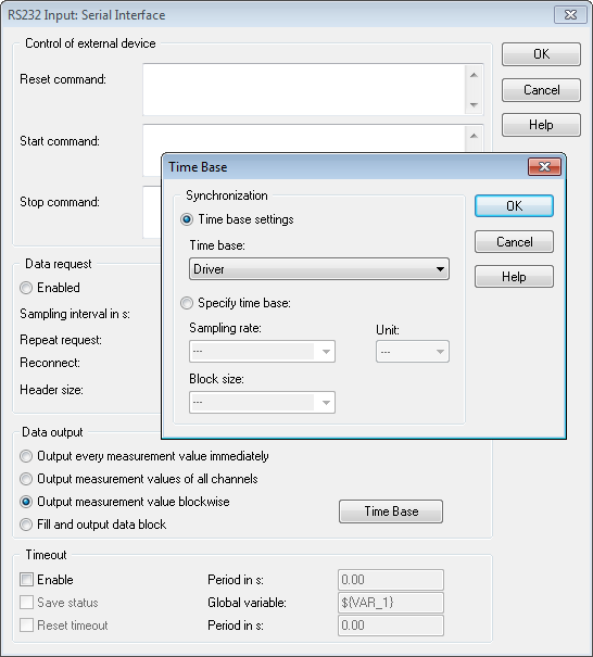
That's what I needed. Your time is the driver. In the RS232 input module, click the Options button.
Select the measurement of output value, and then click the button on the time Base and select sync/time Base driver.
That should allow you to write to the DDF file.
-
Hello world
I use a module in series or with cRIO 9870 9014. I have need to acquire analog data with the GPS data and lang + long for each data point.
I am able to get to the host vi gps data, but I am confused about the acquisition rate. I was curious and place a control on front panel to watch the gps in my RT vi data and I see a lot of spaces. (photos attached). I watched a lot of good examples on gps with the readers of visa, but since I'm on a cRIO with a TCP connection, I don't know how to process the data of succession on the controller.
Can anyone help me please with ideas to use the module straight series.
Thank you
Tamanna
Since it is a serial connection, you need to be constantly read the 9870 on the FPGA. Even if your gps only updates once a second, that "update" has strings of unsigned 8 bit integers representing all of your characters - each read one of these U8s, seize only if you read at 1 Hz, will NOT correct data.
So... Read on the FPGA continuous, faster better and passing in a FIFO to pass off to the host so that you can decipher your data. You may need to adjust timeouts on i/o reads. Definitely take a look at the examples in the example for communication finder series with this module.
And... as a diagnosis... you should be able to do this easily plug into the port series to your controller and use the controls VISA ON THE HOST RT - ethernet connection has nothing to do with it.
For diagnosis, the indicators more the better. Let me know if you more specific issues.
-
Where is able to select the GPS data source?
Hi, guys.
I have a question about the GPS.
I want to know the source of GPS data.
I think that 2 types of sources of GPS data as internal device of GPS and Bluetooth GPS Receiver.
If the user has a BB with chip GPS and Bluetooth GPS Receiver, where it is able to resolve?
And I thought that this version of the OS 4.2 and 4.3 and 4.5 - 4.7 have different parameters to set the GPS data source option.
Thank you guys.
Hello
The GPS data source is available for consultation in Options - Advanced search - GPS. If you do not have an entry Advanced Options (pre - 4.3 software) then you should see a GPS option on the first screen of Options.
Kind regards
Mike.
-
5 Lightroom sometimes fails to load EXIF GPS data from .jpg files
Until I Lightroom, I used geoSetter to add GPS data to my .jpg files. Most of them have loaded up in LR without problem, but for some of them, Lightroom could not import the GPS data. I used to compare GPS data in the loaded files OK and those who have not noticed that some of the problem files do not have exiftool: GPS, GPS Time Stamp, dater GPS map data. I used exiftool to change these in the file, Lightroom still not managed to load GPS data. Anyone has an idea why Lightroom 5 sometimes fails to load EXIF GPS data from .jpg file
= P3207532.jpg - data from GPS not imported into Lightroom
ID of the GPS Version 2.2.0.0
GPS Latitude Ref North
GPS Longitude Ref is
REF Altitude GPS altitude
Time GPS 2015:03:20 02:18:36Z
GPS Latitude 20 deg 54' 41.68 '' N
GPS Longitude 107 deg 0' 5.47 "E
GPS Position 20 deg 54' 41.68 '' N, 107 deg 0' 5.47 "E
= P3207533. JPG - Imported data GPS OK in Lightroom
ID of the GPS Version 2.2.0.0
GPS timestamp 02:22:26
GPS map Datum WGS-84
GPS Date Stamp 2015:03:20
Time GPS 2015:03:20 02:22:26Z
GPS Latitude 20 deg 54' 43,41 "N
GPS Latitude Ref North
GPS Longitude 107 deg 1 9.10 ' E
GPS Longitude Ref is
GPS Position 20 deg 54' 43,41 "N, 107 deg 1 9.10 ' E
= P3207532.edited.jpg - data from GPS not imported into Lightroom
ID of the GPS Version 2.2.0.0
GPS Latitude Ref North
GPS Longitude Ref is
REF Altitude GPS altitude
GPS timestamp 02:22:26
GPS map Datum WGS-84
GPS Date Stamp 2015:03:20
Time GPS 2015:03:20 02:22:26Z
GPS Latitude 20 deg 54' 41.68 '' N
GPS Longitude 107 deg 0' 5.47 "E
GPS Position 20 deg 54' 41.68 '' N, 107 deg 0' 5.47 "E
The problem with P3207532.jpg is that it contains two sets of GPS, a values in the section of EXIF metadata in the XMP metadata section:
$ exiftool -a -G P3207532.jpg | grep -i gps
[EXIF]          GPS Version ID                  : 2.2.0.0
[EXIF]          GPS Latitude Ref                : North
[EXIF]          GPS Latitude                    : 20 deg 54' 41.68"
[EXIF]          GPS Longitude Ref              : East
[EXIF]          GPS Longitude                  : 107 deg 0' 5.47"
[EXIF]          GPS Altitude Ref                : Above Sea Level
[EXIF]          GPS Time Stamp                  : 02:22:26
[EXIF]          GPS Map Datum                  : WGS-84
[EXIF]          GPS Date Stamp                  : 2015:03:20
[XMP]          GPS Date/Time                  : 2015:03:20 02:18:36Z
[XMP]          GPS Version ID                  : 2.2.0.0
But the XMP section contains an incomplete set GPS fields. Note that XMP:GPSDateTime specifies a time other than EXIF:GPSTimeStamp.
I don't know which of your programs may have created these XMP values false, incomplete, but they confused LR. According to the specifications of the Working Group of the metadata, which accepted LR, LR, choose the EXIF GPS values and false XMP values should not confuse it. But LR is preferring the XMP values and then conclude it is not all the GPS coordinates.
You can work around this bug in LR by doing:
ExifTool - xmp: gpsdatetime = - xmp: gpsversionid = file
-
I am under Lr 2015.2.1 on an iMac, I just upgraded to a 5 D Mk3 and equipped with a gps, the camera display gps data on the screen of the device, but when imported it just do not come with it! How can I get these upcoming data with images.
I found that my "preset import' is the problem, once I have stop this is great! When using without preposition, the image has given GPS, altitude, direction & just visible city, State, country and iso code. My reason for making my own preset was to add my contact information and copyright info. And it worked
You can continue to use a metadata import preset that sets coordinated and copyright, but make sure that the chosen preset camera of uncontrolled information:

After importation, over the "metadata" Information Panel has drop-down menu called preset and in this 'none' displayed always, even if the required data had applies. (contact & copyright).
The box preset in the metadata Panel never shows what preset eventually applied on import. It shows that what has been recently applied after importation.
-
How do you find the photos which are not geotagged - have no gps data?
As I struggle to learn Lightroom CC spend opening I'm stuck on how to find the files that have no marking of gps. In library view if I click on the arrow to the right of the info from GPS field in the metadata I takes me directly on the card module and it displays the image on the card. This method differs by clicking the arrow to the right of, say, the lens area where metadata selector arrives so I can choose among various options of metadata.
In short, I want to find all images in a folder that have not been geotagged.
View > show filter bar. Click on metadata, and then set the first column of GPS data. Click any coordinate:

-
How do you add gps data to a photo in Adobe Photoshop cc2015?
How do you add gps data to a photo in Adobe Photoshop cc2015?
Enter the information in Bridge:


Maybe you are looking for
-
Lightning fails after update to Thunderbird
Hi Guy, I have updated Thunderbird to the latest Version and now Lightning does not seem to want to re-populate. It will not allow me to switch between different displays (Day, Week, Month). Also the TASK entries are no longer available. How do I re-
-
Finally, you have a recovery CD, but how to use it?
Hello, after months of trying I finally got my self a product recovery CD https://backupmedia.Toshiba.EU/landing.aspx I hope it was the right place to get one, as it was the only one that I could find. In any case I have as far as I know I have keep
-
Equium M50-216 (PSM57E) - where can I get drivers after reinstalling the OS?
So basically this is my problem. Thanks ;--)
-
ENVY dv6-7214nr - mSATA does not start
ENVY of HP dv6-7214nr - 8.0 Windows (x 64) I installed a KINGSTON 30 GB (KINGSTON SMS200S330G) mSATA with 8.1 Pro N (x 64) Windows on this subject, to use as a boot device. The system recognizes the new hardware, but when I try to set the mSATA as th
-
Solve linear equations - Block tridiagonal matrix
Hello I developed a vi that can be used to solve tridiagonal systems by block of equations by Thomas algorithm. These systems are usually in the finite differences method used to solve equations in partial derivatives. For iterations of 1000 times, i